
It’s that time of year again and the Victorian High Country will be opening up to 4x4 drivers once more. Here are our top three 4WD tracks to check out first.
Tucked away in the northeast of Victoria, the Vic High Country is a mecca for outdoor enthusiasts, history buffs and adrenaline-seeking 4x4 drivers alike. It’s home to dramatic and rugged landscapes, charming villages, iconic pubs and some fantastic remote campsites.
As an alpine region, a number of roads and tracks close in the Vic High Country during the colder months. Most of the seasonal road closures begin after the King’s Birthday long weekend in June and reopen around the Melbourne Cup long weekend in November. However, this comes down to the weather and track conditions, and the dates can be extended if the tracks are deemed unsuitable and unsafe (for both four-wheel drivers and the track itself).
It's important to always check the Parks Victoria website for the latest information on seasonal and regular road closures in the High Country before you set out.
The Vic High Country’s 4WD tracks are renowned for being difficult, and they’re advised for experienced 4x4 drivers only. Make sure you’ve got all the essential gear, including recovery equipment , reliable navigation and comms devices and a high clearance vehicle that is up to the task. If you’re travelling in spring and autumn, be ready for cold nights and pack accordingly.
So, now that the general housekeeping is covered, let’s dive into three of the Victorian High Country’s must-do 4WD trips.

Wonnangatta region
The Wonnangatta region is home to some of the Vic High Country’s best and most popular 4WD tracks and locations and is somewhat a rite of passage for anyone wanting to go on a Vic High Country adventure.
There are plenty of campgrounds and small towns where you can set up a base camp and explore the region, including Dargo (the iconic Dargo Hotel is an absolute must and a great place for good pub grub and country hospitality). But for campgrounds we recommend heading to Talbotville Camping Area. The drive up along Crooked River Track has several river crossings, but it’s well worth the effort, and from here you’re in a great position to explore the various sights and tracks in the area, including Billy Goat Bluff and Wonnangatta (Zeka Spur).
Billy Goat Bluff Track

The Billy Goat Bluff is one of the Vic High Country’s most challenging yet spectacular 4WD routes. This 132km drive from Licola to Dargo (or vice versa) will take you along some of the Vic High Country’s most exposed routes, and while it might have you on the edge of your seat, the great views are worth it.
The route can be completed in a day, but we recommend allowing two so that you’re not in a rush and can enjoy some of the many stops and hikes along the way, including the hiking trail to Lake Tali Karng.
Billy Goat Bluff does have many steep climbs and descents and various water crossings, so make sure your 4WD has high clearance and low range.
The route
Departing Licola, head north on Tamboritha Road. The sealed surface will soon give way to gravel as you enter the forest, driving past Lost Plain Picnic Area before you reach Arbuckle Junction.
At the junction turn east onto Moroka Road. The road will climb up to McFarlane Saddle Trail Head and Camping Area, which is a good place to stop if you want to head on an overnight hike to the hidden gem that is Lake Tali Karng.
Leaving McFarlane Saddle you’ll make the descent down to Moroka River Crossing and then to Horseyard Flat Campground with large grassy campsites available and a classically dishevelled Vic High Country hut to view. Continue along the track to the Pinnacles Fire Tower and lookout.
From here, the Billy Goat Bluff Track heads north on a narrow, rocky and very exposed ridgeline. Take it slow and steady, heading down to Wonnangatta Road. Once you reach it, turn right and keep going past Kingswell Bridge until you reach Shortcut Road which will take you to Dargo, where you can enjoy a well-deserved respite and cold drink at the Dargo pub.
Wonnangatta (Zeka Spur) Track

The best thing about this region is that you can create your own road trip using the various tracks. Once you’ve ticked Billy Goat Bluff off your list, you can then head over to the Wonnangatta (Zeka Spur) Track, a 193km drive between Dargo and Licola.
Due to the length and challenging terrain, it’s best to allow two days to complete it, and thankfully there are plenty of camping areas to utilise along the way.
Difficulty wise, the track is predominantly graded as medium with a few short sections that are more difficult and require high clearance and low range.
The route
From the Dargo Hotel, head south down Dargo Road to Shortcut Road, where you’ll turn west onto Crooked River Road and head towards Kingswell Bridge.
Once you reach Kingswell Bridge, head to Wonnangatta Road and then turn onto Eaglevale Track, which will lead up to Wombat Range Track. As you follow this track north to Humffray River you’ll pass the steep and challenging Herne Spur Track and cross the Humffray river three different times before you reach the Wonnangatta River.
Following the Wonnangatta Track make sure you stop and check out the old Wonnangatta Station which is the location of two of the Vic High Country’s most renowned and unresolved murders which happened in 1917 and 1918. Once you’ve finished having a look around, continue along the Wonnangatta Track until you reach the Zeka Spur Track.
Take this 22km section of the route slow and steady and you’ll soon reach Howitt Road. Turn south onto the road, continue on past Howitt Hut (or stop to check out the hut and enjoy the camping area) until you reach Arbuckle Junction. From here it’s a simple 45km drive south on Tamboritha Road to reach Licola. And if you haven’t quite had enough of the Vic High Country lifestyle, stop in at one of the many great campsites along the Wellington River before trying out the next track on the list.
Blue Rag Range Track
If you’ve had the Vic High Country on your travel bucket list, chances are you’ve seen some pictures from this iconic track. It’s one of the most beautiful and scenic drives in the area, but no less challenging because of that. It’s a 113km track from Dargo to Hotham Heights, and while it might not take you all day, we recommend allowing at least a day so you don’t rush yourself and your 4WD along the rocky sections (high clearance is required).
For those who want a break from the adrenaline, you can get a fantastic view of the Blue Rag Range Track from the bottom of the Wonnangatta valley.

The route
Leaving from Dargo, you’ll drive north on the Dargo High Plains Road, but it won’t be long before you’ll want to pull over. At 26km from Dargo there’s the Treasures (Mt Ewan) Hut, then another 17km down the road the historic Gows Hotel.
Continuing along the track, you’ll drive through an area of fenced grazing land before you reach Lankey Plain Hut. From here you can turn east and follow King Spur Track towards Mayford. Along the way, around 11km after you leave Dargo High Plains Road, there is a clearing with several bush camps. Or continue driving to reach the old town site of Mayford, another good spot to stop, stretch your legs and check out the meagre remains of the town.
If you took the detour, head back to Dargo High Plains Road, or simply continue on from Lankey Plain Hut another 6km until you reach the junction of the Blue Rag Range Track.
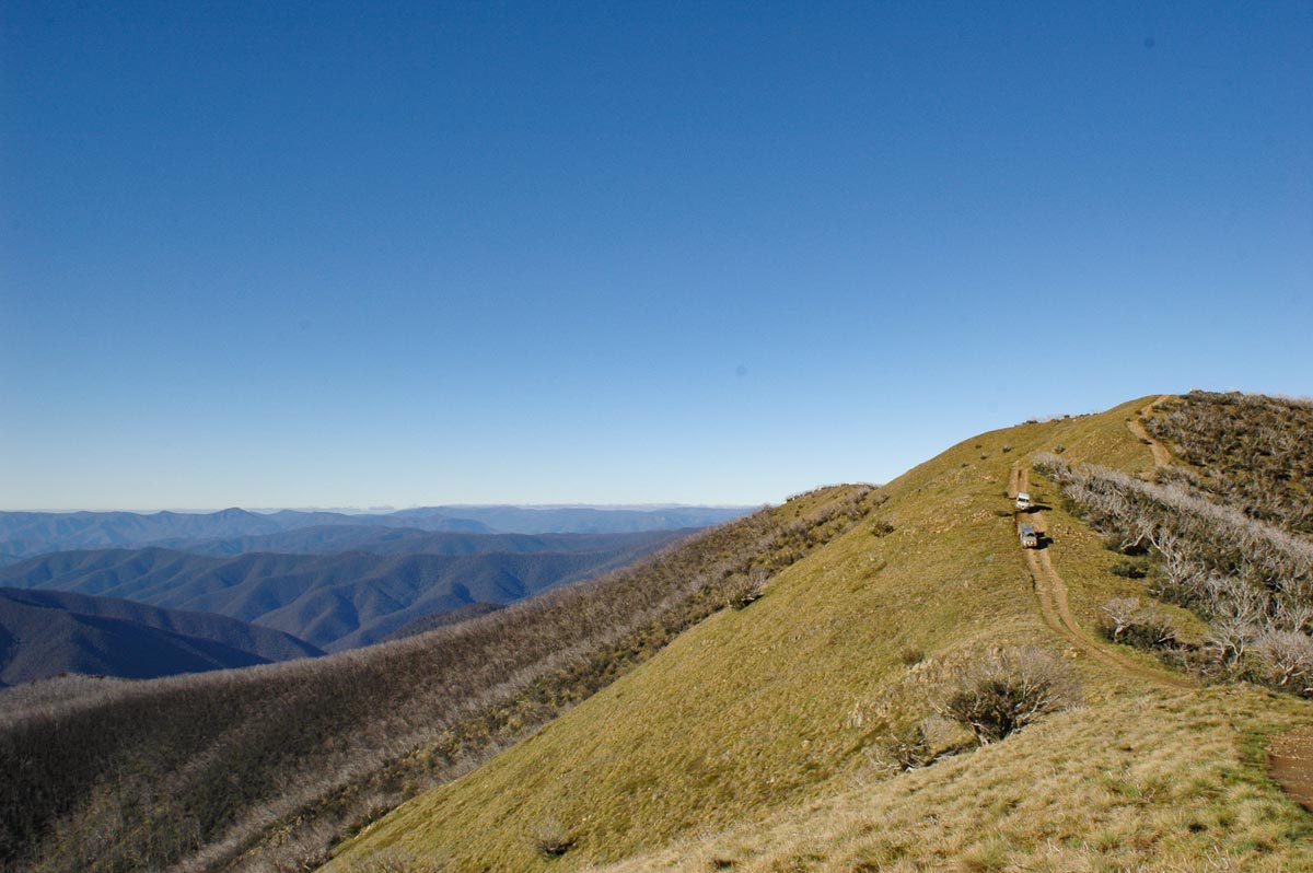
From here, get ready for a steep and rocky ride with views upwards along the winding ridgeline and expansive countryside to each side. There’s a 7km drive until you’ll reach Blue Rag Range Trig Point, where you can stop and enjoy some of the most spectacular views of the Vic High Country.
Please note, while the track might look like it keeps going from here, it’s only a one-way road so we recommend turning around and heading back at the Trig Point to save yourself time, effort and a scratched-up car. So, follow your tyre tracks back to the Dargo High Plains Road.
If you want to explore more, turn left at the junction and head north 12km to get to the Great Alpine Road, then it’s only another 12km to Hotham Alphine Resort , where there are plenty of walking trails and more to be found. Or simply head back down the way you came to Dargo, check out the Grant Historic Area along the way and then find the next track to follow.

Keep the adventures going
These are just three of the popular tracks to complete in this region of the Victorian High Country.
If you want to head a bit further afield, check out Mount Pinnibar Track and Ingeegoodbee Track to the east, both of which are as epic as they are challenging.
Please note, Ingeegoodbee Track was closed earlier this year due to storm and flood damage and repairs are not expected to be completed until late 2024 or early 2025. Always check for updates on the Parks Vic website before travelling.


